• Training
    • Injury Prevention
    • Training Tips
  • How To
    • Bike Fit
    • Gear
  • Nutrition
    • Nutrition Tips
    • Weight Loss
  • Repair
  • Reviews
  • Stories
    • Funny Stories
    • Jokes
    • Quotes
    • Videos
    • Funny Videos

I Love Bicycling

I Love Bicycling is a website that is geared towards cycling for beginners with road cycling tips, training articles, nutrition tips, weight loss, how to’s and bike repair articles.

How Accurate are Google Maps Cycling Directions

January 12, 2016 by Wade Shaddy

google maps cycling

Who says you have to use Google Maps only for driving directions? If you love gadgets and apps, and are looking for an easy way to plan and map out your next ride, try using Google Maps Cycling Directions.  It’s not exactly new as it’s been out for a while, but newer updates have many features that cyclists might find useful.

Google’s Expanding Features

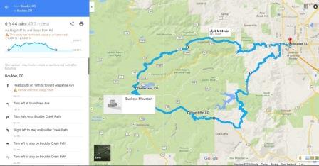
Google should be given credit for investing significant resources over the years in bicycle travel and public transportation in general. Green highlighted trails, bike lanes and bicycle-friendly roads make the maps easy to use and to find routes for cycling. You can create a custom route with detailed, turn by turn directions, mileage and estimated travel times using drop and drag get the route you want. They even have an elevation feature that can tell you how hilly or flat a particular route is.

Locations of Google Maps Cycling Directions

The US and Canada have had Google cycling maps directions since 2010 and recently they added the function in the UK and Europe. But it’s been a bit of trial and error. To find a route, you had to switch between the walking and driving modes, often relying on your own knowledge of cycle paths, shortcuts, highways and generally use a common sense approach to get to where you’re going.

One reason it took so long to get accurate calculations for bike routes is because they can vary so much. In Googles defense for trying to get a handle on all this, they have spent years compiling data about bike lanes, paths, rails-to-trails, and determining bike-friendly street routes to offer its cycling directions map service everywhere. Google has done a good job of that to get the best and safest bike routes on their bike-specific maps.

Average Times

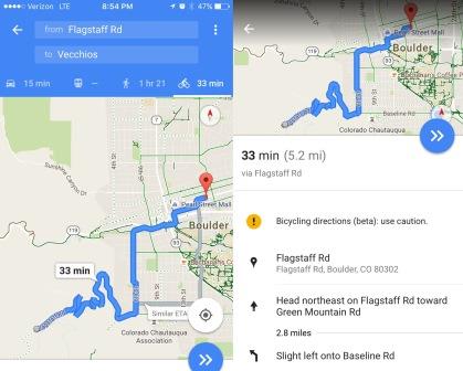
Google Maps cycling directions will also predict your ETA. Most fit cyclists will typically find that the travel times are conservatively on the slow side. For example, a hilly 30-mile route may be projected to take three hours at an average speed of about 10 miles per hour. That’s fine for mountain bikes, but a fit cyclist on a road bike is more likely to do the same route at an average speed of 14 to 16 miles per hour.

At best, you will likely find the estimated times too slow. Basic division says that Google is calculating basic speed at about 12 mph on flat ground to come up with those numbers.

Routes

The directions should avoid the busiest routes which include divided and interstate highways that do not allow bikes. Overall, the Google Maps cycling option most likely provides the best solution in a challenging situation to get from point A to B particularly when you don’t know the area. To avoid any inconvenient obstacles on your route, zoom in and look at the details of where your route is taking you. If it’s going a way you don’t wish to go, there may be a few different alternative routes that come up in gray when your route is first presented to you. You can also select the small dots along your route and drag it to your desired roads or trails. One note on this is that you can only drag your route on a desktop. It’s not a feature on the mobile version of Google Maps.

Viewing All of the Bike Friendly Routes

Besides turn-by-turn routing, Google also offers you the option of checking out all of the bike-friendly routes in your selected region or chosen destination simply by select the “bicycling” layer from the “more” menu in the map. You can then see bike trails and lanes in light and dark green, some that you might not have even been aware of.

Some Exceptions and Things to Look Out For

You’ve all encountered your onboard GPS directing you to drive into the nearest river or off a cliff. Bear in mind that Google Maps cylcling directions may also not be completely accurate, so use caution. And even though you’re less likely to get into an accident with cycling as opposed to driving, there are certain things to look for and question.

  • Roads that are named wrong.
  • Time estimate being way off.

The Two Best Ways to Utilize Google Maps Cycling Directions

The first more obvious way to use the Google Maps cycling feature is to look at the bike paths, lanes, and routes in the area you’re looking to ride for the best way to get from point A to point B. You can then make a mental note or write down the directions but an even better solution is to plug the destination/s in to your phone.

Navigating form the Voice in Your Ear

Once you have your desired route, click the arrow to begin navigating when you have the route you want and plug you earbuds in to your phone. String the cable out of your jersey pocket from your phone and route it up the back of your jersey and over your shoulder with enough extra to make sure it reaches your ear and when you turn your head the ear bud doesn’t fall out. If you’re wearing bib-shorts, you can wrap it once around the suspender on your shoulder to hold it in place. One note with this is to only ever wear ONE ear bud so you can still hear traffic and any other dangers around you. Google Maps will tell you when a turn is coming up and when to turn making it about as easy as it can get to navigate anywhere on a bike. A sweet feature also is that as long as your route is loaded and you ride out of cell service, it will still continue to navigate and tell you where to go.

Google Maps cycling directions and features are a great tool to use for finding routes and navigating. It tends to be pretty accurate as a whole but it does have its bugs so double check your route to make sure you’re on a good route. Let us know how Google Maps cycling directions help your riding and pass the info along to your buddies if they don’t yet know of Googles handy features.

Google Maps Biking App. Adds Elevation to Cycling Maps

January 12, 2016 by Wade Shaddy

google maps biking

Even though elevation data in the Google Maps biking application has previously been available,  Google has quietly added easily accessible elevation data to bike routes in its Maps service, providing better intel. for serious cyclists.

The feature, that actually launched mid-summer, seems to work for much of the U.S. and Canada. Google says although their maps previously factored in elevation when determining routes for cyclists, the data wasn’t as easy to access or apply.

How to Access the Google Maps Biking Elevation Feature

After first imputing two locations as starting and ending points, the feature is accessed by clicking on the bicycle icon in the map’s info box for your directions. The screen should then show you a graph of the elevation changes over the course of your chosen route, along with the highest and lowest elevations and the total elevation changes, up and down. In the elevation profile panel there is an option to hide or show bike paths.  To switch between routes, click on the desired route on the map or on the elevation profile panel.  Taking it a step further, drag the cursor along the chosen route and the graphic shows the elevation changes at any given point.

Using On Mobile

The update, which is currently only applied to the Android version of Google Maps, is not in Google Play yet, but Android users can download the APK here. There has been no time period of when the update will roll out to iOS users. Once you’ve downloaded and installed the APK, the new Google Maps will replace the existing app on your phone.
 As with any external download, the usual disclaimers apply to everyone who chooses to take advantage of this new service.

Accuracy

The new feature is apparently only activated when there’s an appreciable elevation change along the route. For example, the accumulative effect of rollers may not be aptly signatured on the map, and the route may be identified as “mostly flat,” or you won’t see any elevation profile for the route. However, when plotting a known elevation change, the app should inform you of the changes above or below sea level.

Use-ability

The cyclist’s elevation graph is not available in Google Maps’ driving directions, however.Take that, engines.

The feature seems to work for any distance. Even a bike route from Portland Oregon to Portland Texas showed an elevation gain of more than 57,000 feet.

Some of the more intrepid cyclists may already be using Garmin for elevation, and the figures on Google may or may not match what’s on your Garmin; there’s no real answer for this yet. It’s not exactly  clear where Google is acquiring its elevation data from, though its likely that it is an integration with its own elevation data or Elevation API. It’s the software that provides elevation data for all locations on the surface of the Earth, according to Google, including ocean depths, which hopefully, cyclists won’t be using to any extent.

Why Would it Matter?

Have you ever questioned a bicycle route? Lots of roadways, particularly on heavily traveled highway’s such as Highway 101 along the pacific coast, are marked with cycling routes that seem to take you away from the view, or out of your way. More than a few cyclists, using their simple foldable maps, decide to defy the chosen route by taking a shortcut — it’s almost always a mistake. Shortcuts at this point can take you into brake-fumes, exhaust fumes, and some of the most gut-wrenching climbs you can imagine. A simple look at the elevation gain or loss, even if it’s in a short space, can make an incredible difference in your attitude and ride.

Century Planning

Lots of cyclists plan century rides from home, or from a starting point somewhere near or far. It’s nice when your century — or any long distance ride for that matter, works out to be exactly 100-miles. Cyclists have been using Google earth and google maps for years to get the routes perfect. With the addition of elevation to maps, you can avoid the last minute hill-climbs, planning a route around certain obstacles. More itrepid cyclists might choose to add the hills; the google app gives you the ability to do just that.

  • Facebook
  • Tumblr
  • Twitter

Latest Articles

JOIN Cycling: A New Training Platform for Cyclists

May 27, 2024 By Eric Lister

cold exposure

The Benefits of Cold Exposure for Cycling & Life

June 13, 2023 By Eric Lister

hill climb

The Ultimate Hill Climb Training Guide

May 31, 2023 By Eric Lister

shoulder pain cycling

How to Treat & Avoid Shoulder Pain While Cycling

April 12, 2023 By Eric Lister

psoas stretch

The Importance of the Psoas Stretch for Cyclists

April 6, 2023 By Eric Lister

cycling neck pain

The Ultimate Guide to Cycling Neck Pain: Causes and Solutions

March 21, 2023 By Eric Lister

Useful Info

  • Contact
  • Finally, A Global Cycling Club That Is Focused On Community And Love Of Cycling!
  • Privacy Policy
  • Share Your Story!
  • Terms And Conditions Of Use
  • Welcome to I Love Bicycling
  • What Happened When I Stretched Every Day For a Month

Recent Posts

  • JOIN Cycling: A New Training Platform for Cyclists
  • How to Hang Bikes in Your Garage: 4 Inexpensive Options
  • Gravel Bike Vs. Road Bike: Which One Is Better For You?
  • The 6 Types of Mountain Bikes & How to Choose the Best One for You
  • What Is a Touring Bike Good For? 5 Benefits We Know You’ll Love

Search I Love Bicycling

Connect with Us

  • Facebook
  • RSS
  • Tumblr
  • Twitter

Copyright © 2025 · Magazine Pro Theme on Genesis Framework · WordPress · Log in